Sister's Itinerary
May, 1999 |
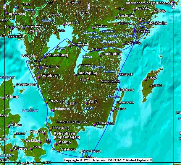
Around Sweden |
|
|
Our route around southern Sweden |
|
This map, produced with DeLorme Eartha Global Explorer, roughly shows the route we followed to circumnavigate the southern part of Sweden in May, 1999. Ellos, the starting point and the village where the Hallberg-Rassy yard is, is too small to show on the map. It is, however, on the island of Orust, which can be seen. |
|
Note the portion of the trip across the middle of southern Sweden. There is a waterway comprised of some rivers, lakes, including Lake Vanern and Lake Vattern, the two huge lakes shown on the map along our route, and two canals, the most prominent of which is the Gota canal. |
The trip was approximately 900 nautical miles long, including a bit of backtracking from Stockholm to the entrance to the Gota canal. Among the highlights of this trip were the Danish islands of Bornholm and Christianso, beautiful Stockholm and the Stockholm archipelago (what we saw of it), visiting Andy's aunts and uncles in Stockholm and Soderkoping and, of course, the Gota canal transit. |
|
For the geographically inclined: The thin, dark, vertical and horizontal lines on the map represent lines of longitude and latitude respectively. |
|
The horizontal lines are very near the top and bottom of the map. The line near the bottom of the map represents 55 degrees North latitude. The line near the top represents 60 degrees North latitude. The 5 degrees difference in latitude means there's 300 nautical miles between the two lines on a North-South line. |
|
The leftmost vertical line very near the left edge of the map represents 10 degrees East longitude. The rightmost vertical line, just to the right of center on the map represents 15 degrees East longitude. One cannot make the same distance inference from the difference between two lines of longitude as one can make from lines of latitude ... unless one is talking about the distance between lines of longitude at the equator. |
|
Click here to see the latitude and longitude of some interesting places. |